
Tags
adventure, hike, hiking, mountain, nature, outdoor, pacific crest trail, photo, san diego, waterfall

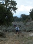
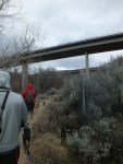
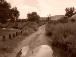
Hiking the Pacific Crest Trail
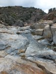
Yesterday, my friends and I ventured off on yet another new hike. We were on a quest to find waterfalls in east San Diego along the Pacific Crest Trail! I say “quest” because it was, indeed, a quest along with an adventure! ***Tip #1*** Always map out where you are going! We arrived along highway 8 around 11:15 am and proceeded to walk east . After 1/2 a mile, we almost reached the top of a paved road we thought, “this is not the right way!” so around we turned and headed back to where we parked. Out came the cell phones to try to map our course. Then, we hiked into a campground and were heading south into the greenery for about 1/2 a mile where we came across flat land that no waterfall would ever live. Turn around! ***Tip #2*** Never rely solely on technology! Right when we were 2 miles deep into our “warm-up” hike, we reached our cars and someone yells, “There’s the trail!” Where was it you ask? Right across the street from where we parked! Now, 12:45 PM, we are headed off onto the Pacific Crest Trail where the hunt for the waterfall begins! We wound back and forth through the hills and to our surprise- finally! We found it- I think! When I think of waterfalls, I think of Hawaii- tall, beautiful bodies of water falling from the sky. It was technically a waterfall but maybe we should have hiked further back! All in all, it was a wonderful adventure full of surprises and a great 6 (or 7) mile hike and I will definitely do it again!!


Such an amazing trail!
LikeLike
I know! We need to go back further to discover more!
LikeLike
thru-hike it! Then you can see the whole thing! : )
LikeLike
I love all te pictures in your posts. I have to remember to bring my camera out with me on my rucks.
LikeLike
Beautiful photos! Looks fun!
LikeLike
Thanks! It was fun!
LikeLike
Ahhh yes, I always have to map out (or at least vaguely have an idea) of where I’m going or I end up at dead ends, a short loop, etc. I try to just always carry one of the paper trail maps on me now (normally they are available at major trail heads or online). I’ve ventured a little too far from time to time because I think I’m going the right way 😉 Sounds like a good hike!
LikeLike
I think I’m going to carry a map with me too! I love an adventure and not knowing where you are going sometimes but getting lost is not cool! Especially when you aren’t prepared!
LikeLike
Totally! Had this happen to me this weekend- check out my post. Won’t be hiking without a trail map- especially on days when I have limited time!
LikeLike
Great job finding it. I’ve been in search of a waterfall off the 8 before, east of San Diego, and have yet to find the elusive visage. Could have been because it was July…
LikeLike
Yesterday I talked to my friend who has seen it and said it was about 4-5 stories tall and can run all year! I really need to go back to find it!
LikeLike
4 to 5 stories tall? Wow. Well, then we both need to head back out and try to find that one then. I mean, how did we miss it?
LikeLike
We saw the stream but didn’t go back far enough because it was freezing out there this last weekend! I’ll let you know if we find it and you do the same!
LikeLike
Pingback: A Year in Review | Girly Camping®